 A couple of weekends ago, Rich and I (and a few friends) did the Tongariro Alpine Crossing. For me and Rich, this was the third or fourth try, previous plans having been scuttled by the weather. On this day though, finally, the weather was near perfect, even if Ngauruhoe was wearing it's best "come on if you think you're hard enough" face at dawn when viewed from our lodge (click on all pics to embiggen):
 Approaching the trail head there was still a sense of foreboding from Mt Doom. The cloud across the saddle to at left where we would be walking was still a slight cause of "will we get to do this or not" angst.
 The start of the trail, already above the treeline at 1100m / 3600ft.. The small fuzzy thing is one of travelling menagerie of photo mascots. This one is a Wombat I picked up in Australia one time.
 The first part of the trail up the Mangatepopo Valley is gentle ambling, even boardwalked in places.
 At the end of the valley though there is this sign as a warning that you are entering a serious environment, and the trail is about to get a lot harder (note the 'you are here' pointer and where it is on the track profile).
 The sign is there partly because of this bit, popularly known as 'The Devil's Staircase'. It has been civilised partly in the past few years with the introduction of a graded trail and actual stairs, but prior to that some clambering over lava flows and finding your own way was required. I wonder if the old way might have been slightly easier, since it might have given more chances for quick breaks. For whatever reason I found this bit easily the hardest part of the crossing. I remember lots of stopping to get my breath back, and sweat dripping off my fingers. It is basically a 1000ft high set of stairs and ramps, with few chances to rest without stopping completely.
Lava, Devil's Staircase
 About halfway up the staircase is this sign reminding exactly what sort of country you are in. the bit of lava flow it is placed on only dates from 1975. It was kind of cool knowing I was walking across ground that was only months older than me rather than the usual millenia.
 Hikers ascending Mt Ngauruhoe. Being a very young (2500 years, it's just a baby) and almost perfectly symmetrical cone, there isn't an easy way up.
 After topping the staircase, South Crater at about 1660m / 5450ft is blessedly, sweetly flat, although another steep climb looms beyond. Also note the numbers on the trail. This isn't exactly a solitudinal thing.
 Looking out over the Oturere Valley at an old lava flow.
 View of the trail during the climb out of South crater showing how well trodden it is. Since this was also another sloggy and hard ascent this was mostly my view of the trail at the time as well.
 Distant figures visible on the summit of Mt Ngauruhoe (2287m / 7500ft). The secondary cone they are standing on only dates from the 1950's.
 Following the ridge between South and Central craters to head toward the Tongariro summit. the landscape is barren and almost alien, as well as being obviously young and violently formed.
 The Wombat triumphant near the Tongariro summit.
 The summit of Red Cone, the highest part of the main crossing route at 1868m / 6128ft. Looking down on it from the ridge above was the highest I have ever hiked.
 Looking into Red Crater at a lava tube exposed by erosion. It is technically called a lava dike, but we quickly came up with a slightly less scientific description for what it looked like...
 Steam rising from the ground atop Red Cone.
 The crazy steep scree slope descent from Red Cone to the Emerald Lakes.
 The scoria and lava flow littered floor of Central Crater looking across to the North Crater cone.
 Looking back across Central Crater at Red Cone, with Ngauruhoe behind.
 Blue Lake Crater, 1725m / 5660ft.
 Looking across Central Crater at the lava flow that spread across it from Red Crater about 1800 years ago.
 Rounding a corner leading away from the Central Crater rim you suddenly get an epic lake vista. Lake Rotoaira in the foreground with Lake Taupo behind.
 You can even see the road marking the end of the trail.
 Which is a bit of a tease since there are still 8 K to go.
 After descending past the tree line, the trail passes through native bush. This bit takes forever, since you know you are near the finish, but can't see it, combined with lots of hard packed earth, steps and drop offs for weary feet and legs. Only a little bit of it is boardwalked.
 The shelter at the end of the trail littered with tired people waiting for their rides.
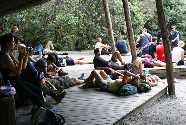 And my own tired dusty feet.
 Team photo post crossing, still smiling, but looking forward to a cold beer.
 Finally getting to take my boots off back at the lodge. Note the gravel that had travelled all the way from the scree at Red Crater.
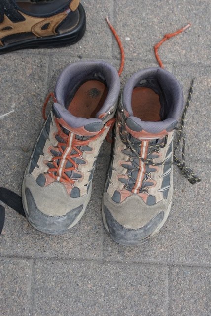
Some post crossing thoughts:
-It was awesome, and a great experience. I like volcanoes and getting to play around and explore in one was a buzz. I will never look at Ngauruhoe and Tongariro in quite the same way again.
-We were very lucky in getting near perfect weather for the day. The weather in NZ is notoriously changeable, and even more so in the mountains. It can go from great to greivous in the space of minutes.
-With the weather in mind I had a heavy pack full of things I wound up not needing, but wouldn't consider going into that environment without. The trail was busy though, and even though I was expecting it, the lack of appropriate clothing or gear among many of the others on the trail, mostly tourists was still head-shake inducing. There were many who were well prepared looking as well, but a lot seemed to have no idea of how potentially hazardous the place is. Which isn't to say it is implicitly dangerous, but you do need to be a bit thoughtful and prepared.
-I wonder how many tourists in particular are surprised not only by the weather changing, but by how difficult parts of the crossing can be. I hard heard of the Devil's Staircase and its reputation, but was still surprised at how hard I found it. Even the 'are you sure' sign might go over the heads of some. This isn't really a casual day walk.
-I want to do it again, but take a bit more time. Our group did the crossing quickly, with little time for the side trips. I would also like to summit Ngauruhoe, at some point. We had thought of it as a 'maybe' this time, but that quickly became a 'no' on getting up there.
-I was expecting to be sore afterwards, but was surprised when I had to take a day off work a couple of days later due to being barely able to walk. I felt like I had two sprained ankles, but they returned to normal after a day or two. I think it was just bruising incurred on the descent, which is swift and on a hard packed trail due to the numbers walking it. This is about the only time on a trail I can remember being happy to walk in mud where I found it.
More pics on facebook here for those interested.
5 comments:
Looks really cool! I'd probably be able to do it but it would definitely be a challenge. For now I will live vicariously through the pictures. Very awesome.
I knew your photos would be orsum - I am looking forward to getting a few copies for my photo album...
R
Thanks Maureen, I'm sure it would be within your trekkng ability judging by some of the stuff you have posted :) You'd also be better at figuring out the different kinds of rock and soil than me I'd wager.
Thanks Rich, next time you are around you can have a look at the raw shots and pick the ones you like.
WOW! I am so jealous. What an incredible trek. Hopefully, I will get to do it some day:)!
Thanks, 'wow' is right. I said that a lot while I was up there. Parts of it are just spectacular. It was tiring to be sure big fun, (hint: don't go trekking with swiss people who live on mountains if you want a slow trip :) ), but big pic fun along the way.
Post a Comment