Showing posts with label Geology. Show all posts
Showing posts with label Geology. Show all posts
Friday, August 23, 2013
Just when you thought it was safe to go back in the water
So a week ago, it's Friday afternoon, and I'm at my desk, the aftershocks from last month's quakes have pretty much died away and things have been feeling normal in that regard for a little bit, when this bad boy happens, and suddenly I'm under my desk waiting for it to stop. Which seemed to take ages. This was the first of the recent series I have felt somewhere other than at home, and away from the bedrock of that locale it was a lot more intense. That was the first time I've ever for real jumped under a desk or table in an earthquake. And I'd do it a couple more times that afternoon as more aftershocks came through. Not fun.
Sunday, July 21, 2013
Well this is getting old
Hot on the heels of Friday's rocking and rolling, we have had today's memorable events.
This bad boy in the morning woke me from a doze to wonder if one of the girls was jumping on the bed (something it took about a second to realise couldn't be true), before waking up and heading to the doorframe to join the rest of the family.

Then right on tea-time it's bigger brother showed up.

I was just walking out the back-door to bring in the washing when it kicked off. I ran back in to fetch Sophie from the lounge (who at 2 seems impervious to the shakes so far), and paused in the lounge doorway to wait and see what was happening. A cry from upstairs revealed that Charlotte (who at 4 is not quite so ambivalent as her sister) had been woken from her nap and was most displeased at the house going all wobbly again. Fi had now appeared in an adjacent doorframe, so thrusting/throwing Sophie at her I ran upstairs to meet Charlotte coming down. Second babe in hand I went back down and waited for the shaking to stop. While our heartrates settled down, a plan was hatched to sort out who goes for what babe in future, and Charlotte instructed to wait for us in a safe place. Just in time for the aftershock about five minutes later
I've discovered that the big slab of peneplain my house sits on manages to insulate us from most things below a 5.0 or so in this sequence, so we've been spared most of the aftershocks, and the worst of the main shocks. The damage around the city though is of a kind I don't recall seeing here in my lifetime, with at least one person I know having their inner city apartment trashed, and the CBD closed for inspection until at least noon. The preliminary report from GNS gives a 1 in 3 chance of a similar size quake within the next week, and a 1 in 5 for the next 24 hours. That's not encouraging.
Post script: On pondering what the shakes actually feel like, and it feels obvious to say it, the big shakes have a palpably different feel to them. They aren't just little shakes writ large. They have more heft, more bass (the bass component is a wierd one to explain), more everything. The little ones tease with the possibility they may get bigger. The big ones leave no doubt they mean business.
This bad boy in the morning woke me from a doze to wonder if one of the girls was jumping on the bed (something it took about a second to realise couldn't be true), before waking up and heading to the doorframe to join the rest of the family.

Screengrab via Geonet.org.nz
Then right on tea-time it's bigger brother showed up.

Screengrab via Geonet.org.nz
I was just walking out the back-door to bring in the washing when it kicked off. I ran back in to fetch Sophie from the lounge (who at 2 seems impervious to the shakes so far), and paused in the lounge doorway to wait and see what was happening. A cry from upstairs revealed that Charlotte (who at 4 is not quite so ambivalent as her sister) had been woken from her nap and was most displeased at the house going all wobbly again. Fi had now appeared in an adjacent doorframe, so thrusting/throwing Sophie at her I ran upstairs to meet Charlotte coming down. Second babe in hand I went back down and waited for the shaking to stop. While our heartrates settled down, a plan was hatched to sort out who goes for what babe in future, and Charlotte instructed to wait for us in a safe place. Just in time for the aftershock about five minutes later
I've discovered that the big slab of peneplain my house sits on manages to insulate us from most things below a 5.0 or so in this sequence, so we've been spared most of the aftershocks, and the worst of the main shocks. The damage around the city though is of a kind I don't recall seeing here in my lifetime, with at least one person I know having their inner city apartment trashed, and the CBD closed for inspection until at least noon. The preliminary report from GNS gives a 1 in 3 chance of a similar size quake within the next week, and a 1 in 5 for the next 24 hours. That's not encouraging.
Post script: On pondering what the shakes actually feel like, and it feels obvious to say it, the big shakes have a palpably different feel to them. They aren't just little shakes writ large. They have more heft, more bass (the bass component is a wierd one to explain), more everything. The little ones tease with the possibility they may get bigger. The big ones leave no doubt they mean business.
Friday, July 19, 2013
Nice Day for an Earthquake
And it was. Blue skies, sunshine, light winds.
And a shallow 5.7 out in Cook Strait. News link with awesome koiwoi ucksents here.
And after a friend of mine suggested this track on facebook, I'm shamelessly stealing it. Dodgy quality but one of my favourite videos in one of my favourite places (Te Mata Peak in the Hawkes Bay). Seems appropriate:
Tuesday, March 19, 2013
Free Treasure
One of the things about living in NZ is the ubiquitous green and yellow Department of Conservation markers you see around, particularly in rural areas, and how easy it is to ignore them, or think you'll come back to them some other time. Try not to; you might miss out on some cool stuff.
Near Marokopa there are three such signs, and on one of our days there we decided to check them out, knowing little or nothing about what they described. "We" being my wife and the old friend brothers we were in Marokopa with (seen here in best adventuring/don't-take-my-photo poses), brother's parents minding the kids for the afernoon:
 The landscape around this part of the country is very limestone-y and prone to interesting erosion, as this appallingly lit photograph typifies. I love the view from the backyard of this house:
 Our first stop was at the intriguingly named Natural Bridge at Maungapohue. For a few minutes you walk down an average little river canyon, like so:
 Then suddenly you walk around a corner and are confronted with this, and involuntarily say "Wow" or words to that effect:
 If you are wondering about scale, there is a person at the bottom of this shot. It's cathedralistic.

 As to how it was formed, it's basically a cave with a collapsed roof. If you want to know more, click on this pic and read the info board :) :
 And just a few steps out the other side and you wouldn't know it was there at all.
 Also around the cave are littered eroded rock formations, including fun rocks for offspring to climb through, and intrepid explorers to conquer (note aforementioned DOC marker).


 There are also rocks that look like they escaped from a Jim Henson movie and are about to wake up and start talking to you.
 Moving on from the collapsed cave, a few minutes along the road at Piripri there is an intact one. This photographs about as well as you'd expect a large cave with only ambient lighting to photograph. On a hot and humid summer day descending into the cool gloom is incredibly refreshing.

 And lastly a few minutes back along the road to Marokopa, and the last stop, are the magnificent Marokopa falls:
 All of these things are pretty much in the middle of nowhere, but I love that these things are just freely available to explore and discover at your leisure. I knew nothing about these three things until we stumbled across them, and (taxes notwithstanding), no-one charged us an entry fee to go and look at them, or made us take a tour. We could just take it in on our own terms and in our own time.
Including family selfies when we took the children to see the sights on our way to our second camping destination the next day:
 I am smiling, it's just hard to concentrate on taking the photo as well :).
Near Marokopa there are three such signs, and on one of our days there we decided to check them out, knowing little or nothing about what they described. "We" being my wife and the old friend brothers we were in Marokopa with (seen here in best adventuring/don't-take-my-photo poses), brother's parents minding the kids for the afernoon:


Including family selfies when we took the children to see the sights on our way to our second camping destination the next day:

Sunday, August 19, 2012
Tongariro Cross
When Mount Tongariro decided to remind everyone it is still an active volcano two weeks ago, it was interesting to see the effect on the some of the parts of it I visited when I did the Tongariro Crossing walk at the beginning of last year. The eruption was centred around the Te Maari craters, which aren't on the crossing trail itself, but close enough to ensure it was in the firing line.
Here's how the trail near Ketetahi Hut looked in 2011, with the hut in the middle distance:
 And how the place looked after being ash-bombed. The hut has holes in the roof that go all the way through the floorboards apparently


Here's how the trail near Ketetahi Hut looked in 2011, with the hut in the middle distance:


Both pics NZ Police via Stuff
Wednesday, July 04, 2012
PS it's an Earthquake
So about this time last night, I'm sitting at my workbench in the study, Fi is pottering in the kitchen, and the kids are asleep upstairs. All is quiet when the model shelves beside me start rattling. They do that from time to time in response to low frequency noises like passing vehicles, the washing machine, or earthquakes. Whenever they start their noisemaking my earthquake spidey senses go all a-tingle, but they usually stop after a second or two and I go back to whatever I was doing. This time they don't stop.
After taking a second or two to tune in I notice that we are indeed rocking gently to and fro, and having an earthquake. After discussing this with friends later we'll figure out this was the P wave arriving and doing it's thing. The whole P and S wave (link) aspect of earthquakes is something I learned years ago but haven't thought about for a while and we're about to get a reminder of how they work.
I note the time for later reference, and that Fi hasn't said anything, so I calmly call out "earthquake" to the kitchen without leaving my seat. She doesn't hear me, so I call out again, and this time she responds by rushing to the doorway and urging me to do the same. That I have time to call out twice isn't something I notice at the time, but in hindsight it means the tremor has already gone on longer than usual. It hasn't got much worse yet and I'm thinking it's a pretty good nudge, (but not that bad) but it will probably end in a few seconds so I'll see what it does and ride it out. Fi is a little less blase, and getting insistent, so I get up and head to the doorway.
I've just gotten to the doorframe when the S waves start arriving and the shaking really kicks off, the worst we've ever experienced in this house. Fi suggests we head upstairs to get the kids, but I'm still thinking this will only go for a few more seconds (ignoring the fact that this is already one of the longest tremors I've ever experienced), so again suggest we ride it out. That's when the shaking kicks up another notch, we hear something glass fall over in the kitchen (later determined to be empty beer bottles in the recycling), the house starts creaking and we are both heading upstairs to rescue the little ones. Quite what we would do if the house started collapsing at this point I haven't figured out, especially having just left a spot of relative safety, but parental instinct is a great driver. We've just gotten to the top of the stairs and are about to go charging into the girl's bedroom to grab one each when the shaking eases and stops, followed by that wierd period when you aren't quite sure if the shaking really has stopped, or your adrenalised senses are tricking you into thinking it is still going.
Having determined that the land has returned to a state of quiescence, we look into the girl's room and immediately have to drop our voices as we calm each other down. The bebes slept through the whole thing. One of them may have rolled over, but that is all :).
It turns out to have been a deep magnitude 7.0, which is starting to get up there in terms of destructive potential, but luckily the depth mitigated it a bit. A much lesser magnitude, but many times shallower tremor wrought all the havoc in Christchurch last year.
There's a Geonet backgrounder here, with the Geonet quake report proper here.
And if you want to hear what it sounded like in a Wellington church, the earthquake was captured during a recording session here (lasting a lot longer than I realised at the time).
It was a doozy.
Wednesday, February 22, 2012
Pondering Christchurch a year on
It's a year today since Christchurch got the kind of earthquake that has long been expected here in Wellington.
It has been a day for reflection and pondering, not only for the lives lost, and lives disrupted, but for the things I have noticed for myself in the passing of a year. It has been five years since I have been in Christchurch. I've never lived there, and know few people there. But in the sense it could have been (and will be one day) us, it casts a long shadow.
After seeing what happens to them in a big shake, I am much more suspicious of brick and stone buildings than ever before. I am glad my house is made of wood. I'm not so glad the building I work in is brick and concrete, in a prime liquefaction zone, and apparently urgently requiring strengthening to get anywhere near acceptable code. Whenever I'm in the city I look around and note the buildings that look like the ones that turned to rubble.
In addition to the liquefaction zones, I also now know where the expected tsunami zones are, and when in them occasionally mentally plan escape routes in the unlikely event. I'm also never buying property in Petone or Island Bay :)
My house and our cars now have survival kits and water stored, with more than the recommended three days worth (I wonder if that will be amended now after Christchurch's experience). I get nervous when my cellphone isn't where I can see it or reach it easily. Not because of addiction, but after hearing how people aided their own rescue with them I now try and have it close at all times.
I try not to let the car petrol tanks get too close to empty. If you need to get out of town in a hurry stopping for gas may not be an option.
I noted a little while ago I have started thinking of 'Old Christchurch' and 'New Christchurch'. Old Christchurch is gone, the new one is still forming. A few months ago one of the TV networks showed a google earth overhead shot, then eliminated all of the prominent buildings that have since disappeared. It was quite a representation of just how much has changed. I don't want to be a disaster voyeur, but I wonder if the only way to really understand is to go down there and see it myself. I know that some parts of the Old Christchurch I am familiar with are now utterly changed, while others are unaffected.
The biggest change I have noticed both in myself and peers, is that after a lifetime of passing off earthquakes as local events in a city riven with faultlines, our first reaction on feeling a shake now is to wonder if it wasn't worse somewhere else.
Friday, December 09, 2011
Didn't feel a thing
So after the pronounced earth related jiggery pokery and fuss on Saturday, I didn't feel this one at all yesterday (screengrabs from Geonet.org.nz):
 And the rock beneath our house probably added to me not feeling this one later that day:
 Probably good I didn't feel the first one, since when it hit I was in the site acid store, a small enclosed space with shelves full of big bottles of acids of various kinds. There are certain places I definitely don't want to be in an earthquake and that one is high on the list. Since I happened to be on my feet and moving around I didn't notice the motion, and since I had my mp3 on, I didn't hear any rattling either. My office got a good rattling though according to the people I share it with.
Sunday, December 04, 2011
Why was the house wiggling?
The above was my three-year-old's response to this, which we experienced at my friend's third floor apartment in central Wellington last night (screengrabs from the awesome Geonet, click to enlarge):

Here is what it looked like on the local quake drum:
 After living here for a while you tend to brush off the small ones. A few seconds of shaking and it's back to whatever you were doing, having spent at least the first one or two seconds deciding if you needed to take shelter in a doorway or under furniture (the bigger shakes tend to make that decision an instant one I have noticed). This one got worse after a few seconds, and when they do that is when you really take notice, usually by wondering "Is this IT, the big one?" in my case.
And then when it stops there is always the period where you are wondering if things are still moving or is it just the adrenalin making you think they are. This was the biggest shake for a while around here.
Tuesday, June 14, 2011
Just can't catch a break
About two weeks ago GNS announced some preliminary results (link) from their investigations into faulting in Canterbury responsible for the September and February earthquake events. A key finding was that there was roughly a 23% chance of another temblor in the Richter 6-7 range occuring in the next 12 months.
The media predictably blew up the 1 in 4 chance of it happening, while ignoring the 3 in 4 chance it wouldn't. There is some good extended discussion of what that means and the media reaction at Sciblogs here (including the interesting observation that the risk is no more than Wellington's, although we have always been told Wellington is high risk so I'm not sure how reassuring that is to Christchurch residents).
Unfortunately though, as events yesterday proved, 1 in 4 is still not zero. One blogger's account of yesterdays event is quite telling, not only for what it describes, but also what it implies, and for how routine some things are getting for the residents.
It is strange at the moment to hear people openly discussing on-line whether a major NZ city should be abandoned, or whether it is appropriate to suggest people leave. While hard to take seriously in a wider sense of totally abandoning the city, the fact such a thing is being discussed at all is slightly weird and surreal, and would have been unimaginable still less than a year ago. It will be interesting to see what Christchurch looks like twenty years from now.
Edit: This morning (wed 15th) GNS has revised their estimation to 30%.
Monday, June 13, 2011
Chile Powder*
 The sunset tonight enhanced by the ash from Puyehue-Cordon-Caulle, having arrived in NZ airspace after taking the long way round by heading east from Chile, and disrupting local air travel to a seldom seen degree. During the day the suspended ash is surprisingly noticeable as a very lightly tan coloured haze. Shot from the Kennedy Good Bridge at about 1730, definitely winter at the moment.
*I wish I had come up with that description/title, but credit belongs to a regular on one of the aviation forums I inhabit :)
Thursday, March 03, 2011
Me vs the Volcano
 A couple of weekends ago, Rich and I (and a few friends) did the Tongariro Alpine Crossing. For me and Rich, this was the third or fourth try, previous plans having been scuttled by the weather. On this day though, finally, the weather was near perfect, even if Ngauruhoe was wearing it's best "come on if you think you're hard enough" face at dawn when viewed from our lodge (click on all pics to embiggen):
 Approaching the trail head there was still a sense of foreboding from Mt Doom. The cloud across the saddle to at left where we would be walking was still a slight cause of "will we get to do this or not" angst.
 The start of the trail, already above the treeline at 1100m / 3600ft.. The small fuzzy thing is one of travelling menagerie of photo mascots. This one is a Wombat I picked up in Australia one time.
 The first part of the trail up the Mangatepopo Valley is gentle ambling, even boardwalked in places.
 At the end of the valley though there is this sign as a warning that you are entering a serious environment, and the trail is about to get a lot harder (note the 'you are here' pointer and where it is on the track profile).
 The sign is there partly because of this bit, popularly known as 'The Devil's Staircase'. It has been civilised partly in the past few years with the introduction of a graded trail and actual stairs, but prior to that some clambering over lava flows and finding your own way was required. I wonder if the old way might have been slightly easier, since it might have given more chances for quick breaks. For whatever reason I found this bit easily the hardest part of the crossing. I remember lots of stopping to get my breath back, and sweat dripping off my fingers. It is basically a 1000ft high set of stairs and ramps, with few chances to rest without stopping completely.
Lava, Devil's Staircase
 About halfway up the staircase is this sign reminding exactly what sort of country you are in. the bit of lava flow it is placed on only dates from 1975. It was kind of cool knowing I was walking across ground that was only months older than me rather than the usual millenia.
 Hikers ascending Mt Ngauruhoe. Being a very young (2500 years, it's just a baby) and almost perfectly symmetrical cone, there isn't an easy way up.
 After topping the staircase, South Crater at about 1660m / 5450ft is blessedly, sweetly flat, although another steep climb looms beyond. Also note the numbers on the trail. This isn't exactly a solitudinal thing.
 Looking out over the Oturere Valley at an old lava flow.
 View of the trail during the climb out of South crater showing how well trodden it is. Since this was also another sloggy and hard ascent this was mostly my view of the trail at the time as well.
 Distant figures visible on the summit of Mt Ngauruhoe (2287m / 7500ft). The secondary cone they are standing on only dates from the 1950's.
 Following the ridge between South and Central craters to head toward the Tongariro summit. the landscape is barren and almost alien, as well as being obviously young and violently formed.
 The Wombat triumphant near the Tongariro summit.
 The summit of Red Cone, the highest part of the main crossing route at 1868m / 6128ft. Looking down on it from the ridge above was the highest I have ever hiked.
 Looking into Red Crater at a lava tube exposed by erosion. It is technically called a lava dike, but we quickly came up with a slightly less scientific description for what it looked like...
 Steam rising from the ground atop Red Cone.
 The crazy steep scree slope descent from Red Cone to the Emerald Lakes.
 The scoria and lava flow littered floor of Central Crater looking across to the North Crater cone.
 Looking back across Central Crater at Red Cone, with Ngauruhoe behind.
 Blue Lake Crater, 1725m / 5660ft.
 Looking across Central Crater at the lava flow that spread across it from Red Crater about 1800 years ago.
 Rounding a corner leading away from the Central Crater rim you suddenly get an epic lake vista. Lake Rotoaira in the foreground with Lake Taupo behind.
 You can even see the road marking the end of the trail.
 Which is a bit of a tease since there are still 8 K to go.
 After descending past the tree line, the trail passes through native bush. This bit takes forever, since you know you are near the finish, but can't see it, combined with lots of hard packed earth, steps and drop offs for weary feet and legs. Only a little bit of it is boardwalked.
 The shelter at the end of the trail littered with tired people waiting for their rides.
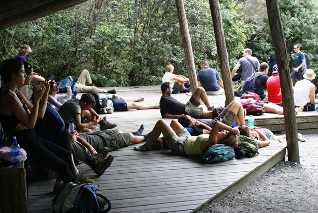 And my own tired dusty feet.
 Team photo post crossing, still smiling, but looking forward to a cold beer.
 Finally getting to take my boots off back at the lodge. Note the gravel that had travelled all the way from the scree at Red Crater.
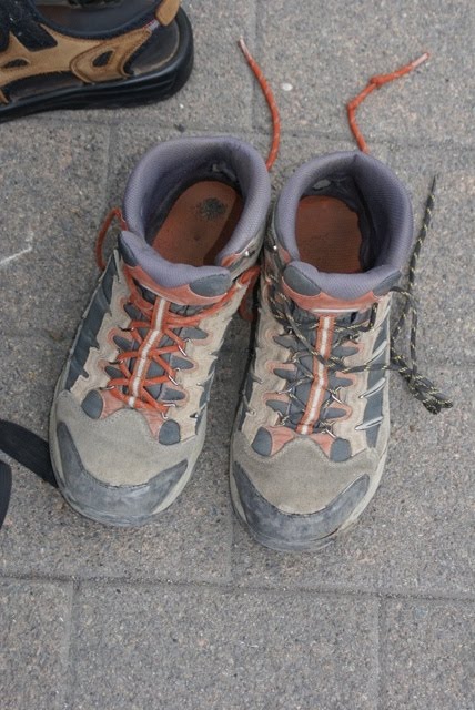
Some post crossing thoughts:
-It was awesome, and a great experience. I like volcanoes and getting to play around and explore in one was a buzz. I will never look at Ngauruhoe and Tongariro in quite the same way again.
-We were very lucky in getting near perfect weather for the day. The weather in NZ is notoriously changeable, and even more so in the mountains. It can go from great to greivous in the space of minutes.
-With the weather in mind I had a heavy pack full of things I wound up not needing, but wouldn't consider going into that environment without. The trail was busy though, and even though I was expecting it, the lack of appropriate clothing or gear among many of the others on the trail, mostly tourists was still head-shake inducing. There were many who were well prepared looking as well, but a lot seemed to have no idea of how potentially hazardous the place is. Which isn't to say it is implicitly dangerous, but you do need to be a bit thoughtful and prepared.
-I wonder how many tourists in particular are surprised not only by the weather changing, but by how difficult parts of the crossing can be. I hard heard of the Devil's Staircase and its reputation, but was still surprised at how hard I found it. Even the 'are you sure' sign might go over the heads of some. This isn't really a casual day walk.
-I want to do it again, but take a bit more time. Our group did the crossing quickly, with little time for the side trips. I would also like to summit Ngauruhoe, at some point. We had thought of it as a 'maybe' this time, but that quickly became a 'no' on getting up there.
-I was expecting to be sore afterwards, but was surprised when I had to take a day off work a couple of days later due to being barely able to walk. I felt like I had two sprained ankles, but they returned to normal after a day or two. I think it was just bruising incurred on the descent, which is swift and on a hard packed trail due to the numbers walking it. This is about the only time on a trail I can remember being happy to walk in mud where I found it.
More pics on facebook here for those interested.
Subscribe to:
Posts (Atom)